Biking, Hiking and Equestrian Trails
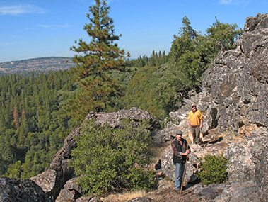
Calaveras County offers outdoor enthusiasts a wide variety of hiking, biking and equestrian trails from gentle rolling foothills strolls to strenuous up country alpine hikes. Below are some trail maps and/or website links to local hiking and biking. See spectacular mountain vistas, beautiful lakeside views, impressive giant sequoia trees, and incredible varieties of wildflowers.
Links to articles featuring hiking and biking: Hike this: Arnold Rim Trail | Bike Angels Camp to San Andreas | The Big Loop
Arnold Rim Trail: Arnold Rim Trail
Calaveras Big Trees State Park: Calaveras Big Trees State Park: Hiking Trails Overview, North Grove Trail Guide and South Grove Trail Guide
Ebbetts Pass Roads: Cycling Ebbetts Pass
Hogan Lake: Cameron Trail Alltrails.com says “Head out on this 10.7-mile out-and-back trail near Valley Springs, California. Generally considered an easy route, it takes an average of 3 h 31 min to complete. This trail is great for backpacking, birding, and camping, and it’s unlikely you’ll encounter many other people while exploring. The trail is open year-round and is beautiful to visit anytime. Dogs are welcome, but must be on a leash”.
Mokelumne Coast to Crest Trail: Mokelumne Coast to Crest Trail
Natural Bridges: Natural Bridges
New Melones: United States Bureau of Reclamation’s list and map of 19 trails around New Melones can be found here: New Melones Trail map This map shows Angels Creek Trail, Buck Brush Loop, Carson Creek Trail, Frontier Trail, Gold Rush Trail and Tower Climb, among others.
Sierra Foothills Trails: East Bay Municipal Utility District’s list of trails, permits and other helpful information including details on Cosa Mesa Trails access point, Patti’s Point, Rich Gulch Trail, Middle Bar through Independence Flat: Sierra Foothills Trails | Mokelumne Area Trails