
Looking for unforgettable hiking trails in Calaveras County? This scenic slice of the Sierra Nevada is home to giant sequoias, volcanic bluffs, canyon rivers, and even a natural limestone cave tunnel. Whether you’re seeking an easy family walk or a full-day challenge with major elevation gain, these curated trails offer something for every explorer.
1. North Grove Loop – Calaveras Big Trees State Park (Beginner | 1.5–2 mi)
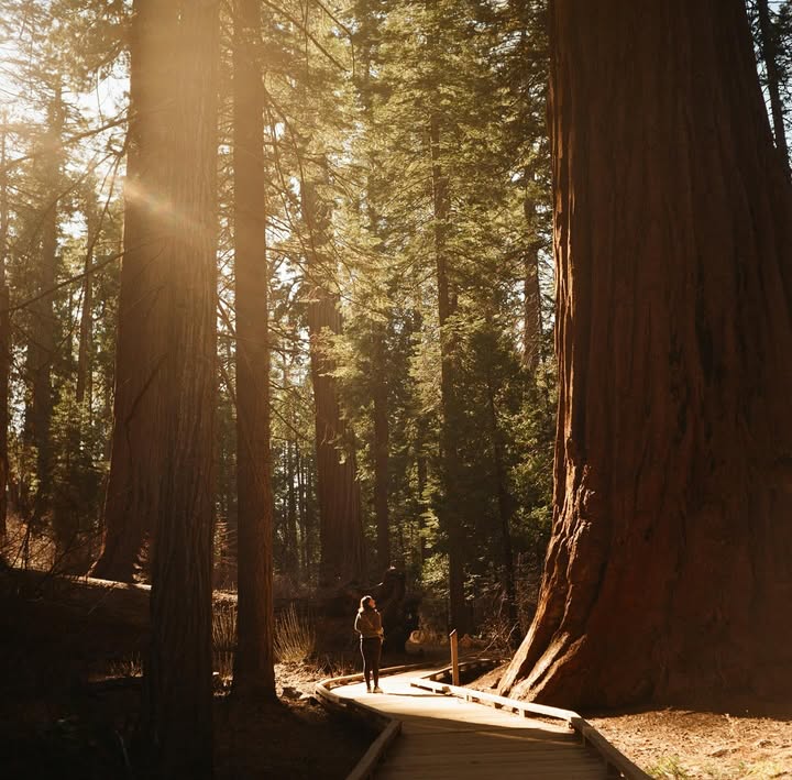
- Trailhead: Visitor Center parking, Calaveras Big Trees SP (Arnold, CA)
- Elevation Gain: ~100 ft
- Trail Highlights: Giant sequoias, Empire State Tree, gentle boardwalk loop. Ideal for families or beginners looking for a short and breathtaking introduction to the Calaveras giant sequoias. $10 park admission
- Dog Friendly? ❌ No
- Best time: Spring through fall for hiking. Snowshoeing available during the winter.
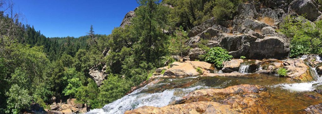
2. Lava Bluffs Trail Loop – Calaveras Big Trees (Moderate to Difficult | 2.5 mile loop)
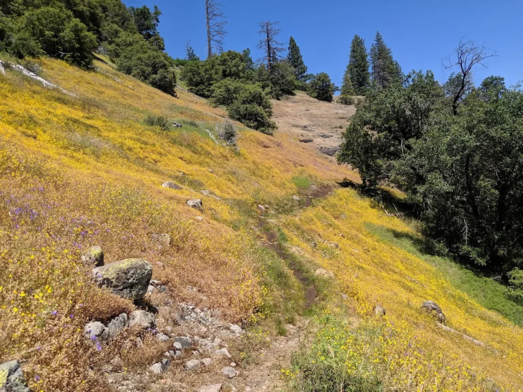
Lava Bluffs Trail – Photo courtesy Sarah Colwell
- Trailhead: South Grove of Calaveras Big Trees State Park/Lava Bluffs parking area
- Elevation Gain: <100 ft
- Trail Highlights: Volcanic rock formations, wildflowers, forest loop. A short and scenic loop that offers geology lovers a walk through ancient lava flows. $10 park admission
- Dog Friendly? ❌ No
- Best time: Spring & summer for the wildflowers. Accessible in the fall with autumn colors.
3. Natural Bridges Trail – Vallecito (Easy–Intermediate | ~2 mi round-trip out and back)
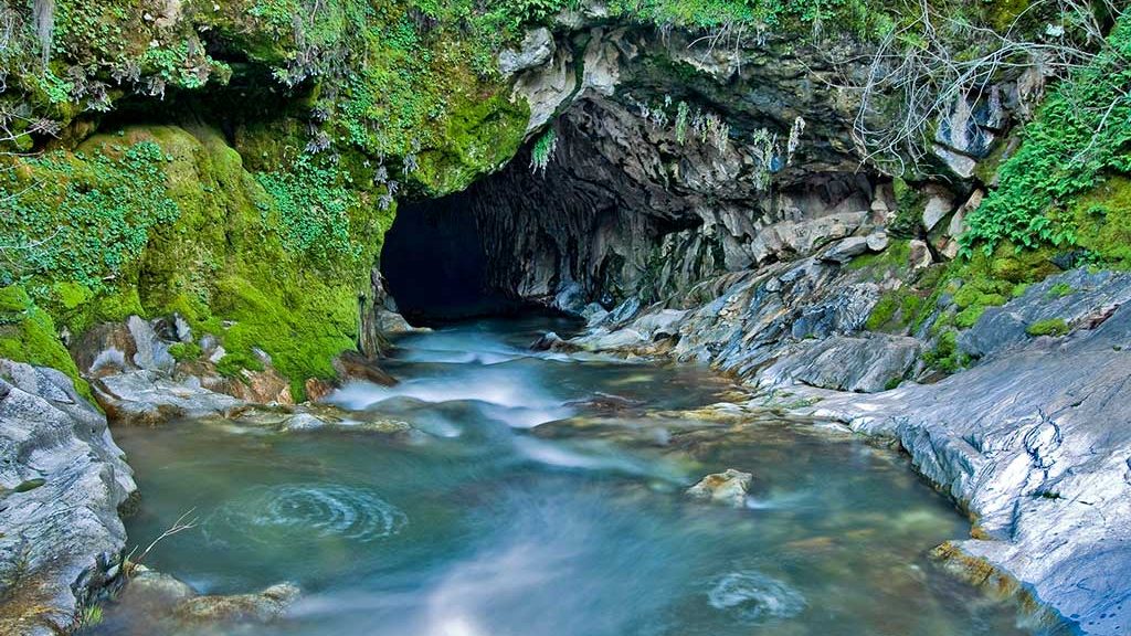
- Trailhead: Parrotts Ferry Rd near Airola Rd (4 mi from Angels Camp)
- Elevation Gain: Moderate, with short steep sections. This trail is one mile down steep terrain in sections, and one mile back up
- Trail Highlights: Limestone cave tunnel, Coyote Creek, swimming hole. Wear sturdy shoes and check creek levels before entering the cave. Descend into a striking limestone canyon and cool off with a summer swim through a natural tunnel. $8 parking fee
- Dog Friendly? ❌ No
- Best Time: Spring when the snow is melting, but use caution as the water runs fast. Summer hikes should be done in the morning or early evening. Fall & winter hikes can be any time because the temperatures are more moderate to cool
4. Carson Creek Trail Loop – Angels Camp (Beginner | ~4.2 mi)
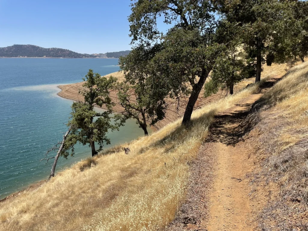
Carson Creek Trail at New Melones Lake – Photo Courtesy Lisa Smith
- Trailhead: Carson Creek Trailhead off Highway 4/Whittle Road parking lot
- Elevation Gain: ~425 ft
- Trail Highlights: Oak woodlands, meadow views, gently rolling hills. Shade for the first half of the trail but not so much for the second half, excellent panoramic views and well maintained trails. Perfect for birdwatching, wildflowers, and relaxed nature walk close to downtown Angels Camp
- Dog Friendly? ✅ Yes (on leash)
- Best Time: The trail is accessible year-round, but spring is the prettiest when everything is green and the wildflowers are blooming. Hike in the morning or early evening in the summer when the temps are higher, and enjoy fall’s mild temperatures any time of the day
5. San Antonio Falls via Arnold Rim Trail – Arnold (Intermediate | ~8.4 mi)
- Trailhead: Near Sierra Nevada Logging Museum & White Pines Lake
- Elevation Gain: 1,100–1,450 ft
- Trail Highlights: Waterfalls, sweeping vistas, forested climbs, high Sierra terrain. Contact the US Forest Ranger in Hathaway Pines for more hiking trails in the Stanislaus Forest at 209-795-1381.
- Dog Friendly? ✅ Yes (on leash)
- Best Time: Spring through fall are great times to hike this trail. Winter, the trail may be snowed in.
6. River Canyon Trail – Calaveras Big Trees SP (Intermediate | ~6.8 mi)
- Trailhead: Near North Grove or South Grove areas
- Elevation Gain: ~1,475 ft
- Trail Highlights: River canyon, wildflowers, shaded climbs. A hidden gem for hikers who want a rugged challenge and river views. $10 park admission
- Dog Friendly? ❌ No
- Best time: Spring through fall, possibly snowshoeing available in the winter
7. Mokelumne Coast-to-Crest Trail – Pardee Reservoir (Easy–Moderate | ~7.5 mi)

- Trailhead: Monte Vista Recreation Area or access roads near Valley Springs
- Elevation Gain: 200–500 ft depending on section
- Trail Highlights: Lakeshore paths, rolling hills, wildflower blooms. This scenic foothill hiking trail near Valley Springs offers multiple loops and lake views.
- Dog Friendly? ✅ Yes (on leash)
- Best time: Year round accessibility, but spring is the greenest with wildflowers bursting through.
8. River of Skulls Trail — New Hogan Lake (Valley Springs, CA – 1 mile Easy Loop)

- Trailhead: Near the Wrinkle Cove Day Use Area off New Hogan Parkway
- Elevation Gain: Minimal (~50–75 ft)
- Trail Highlights: Panoramic vistas of Lake Hogan, basalt rock formations, equestrian trails, wildlife viewing, easy access, quick family outing. Easy, scenic trail perfect for beginners, families, and photographers
- Dog Friendly? ✅ Yes (on leash)
- Best time: Year round accessibility, but spring is nice and green. Summer gets pretty warm, so go in the morning or early evening
Final Thoughts
Whether you’re exploring ancient redwoods on the North Grove Loop, swimming beneath a limestone arch at Natural Bridges, or chasing waterfalls near Arnold, Calaveras County is a premier hiking destination in the Sierra foothills. With hikes tailored to every ability level and rich elevation diversity, it’s a perfect spot for weekend warriors, family adventurers, and nature lovers alike. Call us at the Calaveras Visitors Bureau to find more hiking trails throughout Calaveras at 209-736-0049.
BONUS: Hiking Essentials for Calaveras Adventures

Be sure to bring a hydration pack or a couple liters of water & trail snacks like energy bars, fruit, or nuts. Dress in layered clothing and be prepared for cooler or warmer weather with the elevation changes. Wear boots or shoes with good traction and protect yourself from the sun with a hat, UV sunglasses, & SPF 50+. Its’ a good idea to bring a paper map or GPS app for navigating, a first aid kit, a flashlight (even for day hikes), a whistle, space blanket, back up charger, and a companion! At least let someone know where you’re going to be. Leave no trace – Pack it in, pack it out
